cuteTrac
cuteTrac - Fleet Management
- Introduction
- General Functionalities
- Live Tracking
- Menu-Playback, Zone, Options, Vehicle Groups, Group Visibility, Email, Expenses, Reminders, Others
- Reports
- Mobile Apps
- API
Introduction
Introduction
cuteTrac is a “Vehicle Tracking” application that is used to manage your fleets in real time for operational efficiency. Any types of vehicles can be monitored using cuteTrac application, such as car, truck, bike and boat etc. cuteTrac uses Global Positioning System (GPS) and General Packet Radio Service (GPRS) technology for tracking vehicles in 24X7 basis. cuteTrac ensures accurate live monitoring of the vehicle, also it stores and manages previously tracked data of the vehicles. This document explains cuteTrac (Vehicle Tracking) application for all type of users. It defines the main functions of cuteTrac application and gives detailed instruction on how to use the application effectively. Also it explains all User Interfaces (UI) of the cuteTrac application with well-defined screen shots for your convenience, which provides complete knowledge base of using the application.
Getting Started
Login to Application
To login into the cuteTrac application,
- Open your web browser.
- Type the URL https://www.cutetrac.com in the address bar of your web browser to enter Login page,
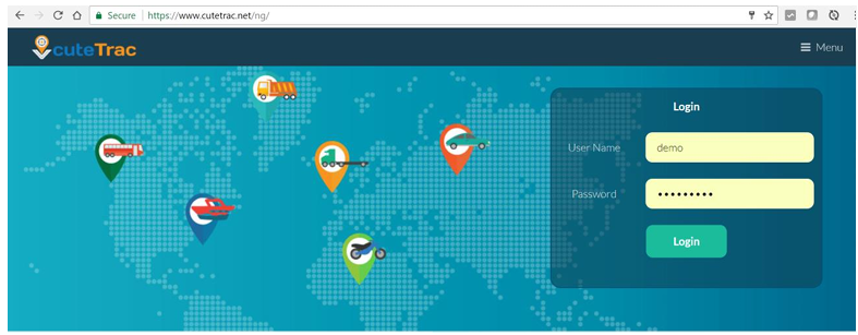
- In the login page, type your User Name.
- Type your Password.
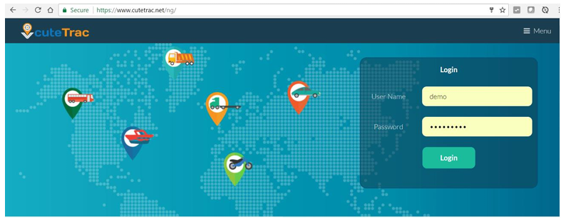
- Click Login. Once you have successfully login into the application, the main page of the cuteTrac will appear. Your user name will display in the top right corner of the application.
Change Password
To change your current password,
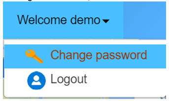
- Navigate to the top right corner of the screen, and click on the drop-down box next to your user name (user ID). There are two options appear. One is “Change Password”, and the other is “Logout”.
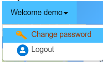
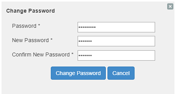
- Click Change Password. Change Password window appears.
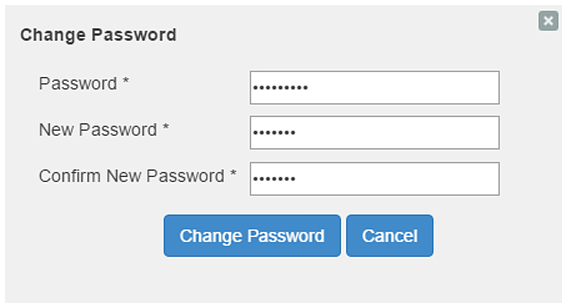
- In the Change Password window, type your current Password.
- Type a New Password.
- Confirm your New Password again.
- Click the Change Password button to save new password.
General Functionalities
Great! Here's the same General Functionalities of cuteTrac section with icon suggestions that you can use when designing the user manual. If you're using software like Word, Canva, or InDesign, you can search for these icons by keyword to match the description.
🚚 General Functionalities of cuteTrac
cuteTrac offers a comprehensive suite of vehicle tracking features designed to enhance fleet visibility, improve operational efficiency, and ensure compliance with usage policies.
📍 Live Monitoring
Monitor vehicle activity in real-time with detailed status indicators:
-
📌 Vehicle Location – View precise GPS-based location on the map.
-
🟢 Engine Status – Check whether the engine is ON or OFF.
-
🚗 Vehicle Speed – Monitor current speed of the vehicle.
-
🧭 Moving Direction – Track the direction of travel.
🔁 Playback History
Replay past vehicle movements with detailed historical data:
🚨 Alert Monitoring
Receive real-time notifications for critical events:
-
⚡ Speed Alert – Triggered when speed limit is exceeded.
-
🕒 Engine Idle Alert – Notifies when idling beyond set threshold.
-
🚫 Prohibited Zone Alert – Alerts when entering restricted areas.
-
🌐 Outside Working Area Alert – Notifies when outside designated zones.
- No Signal Alert: Informs if no signal is received from GPS device
🗂️ Vehicle Grouping
Efficiently manage your fleet by organizing vehicles:
-
👥 Vehicle Groups – Classify vehicles based on region, function, etc.
-
🔒 Group Visibility – Restrict or allow access to certain groups.
📊 Reports
Generate insightful reports to support fleet decisions:
Live Tracking
Live Tracking is one of the key functionality of cuteTrac solution in which the real time location data of all vehicles are displayed on the map. User interface of “Live Tracking” is explained here. Once you have successfully login into the cuteTrac application, the landing page looks as below.
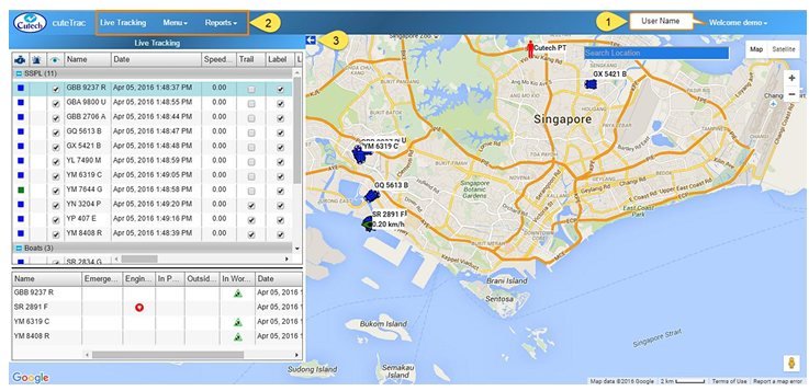
This screen consists following details:
- The user name will display on the top right corner of the screen. Look at the
above figure. - Set of menus display in the top left side of the screen, such as Live Tracking,
Menus and Reports. - The arrow mark at the top right side of the “Live Tracking” window (
 )helps to
expand / collapse the window to the left side of the page. This is useful to
maximize the display when monitoring many vehicles.
Live Tracking Window
Click the  (arrow mark) to expand live tracking window as below,
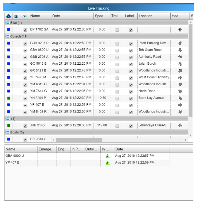
Live tracking window columns legendries:
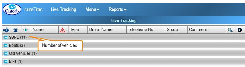
- Vehicle Group button

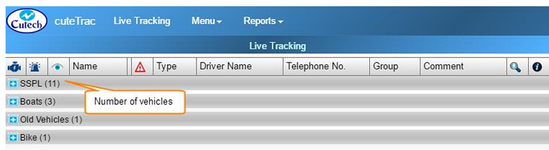
 -The vehicles can be grouped into different vehicle groups for easy management and view when you have long list of vehicles to manage. It can be collapsed and expanded by clicking thebutton provided in front of the vehicle group name such as Boats, Bikes etc..(To refer about creating vehicle groups, refer the Groups Section). Total number of vehicles under each group is shown inside the bracket next to the vehicle group name.
- Engine Status
 -The first column of the window shows Engine Status that varies with different colors. There are three level of engine status you could see in the map, as below,
 Green represents that the engine is turned on.
 Blue represents that the engine is turned off.
 Red represents that no data received from the vehicle for more than 30 minutes. (Either the vehicle is in a GPS hidden area or the GPS needs to be inspected)
- Emergency Alert
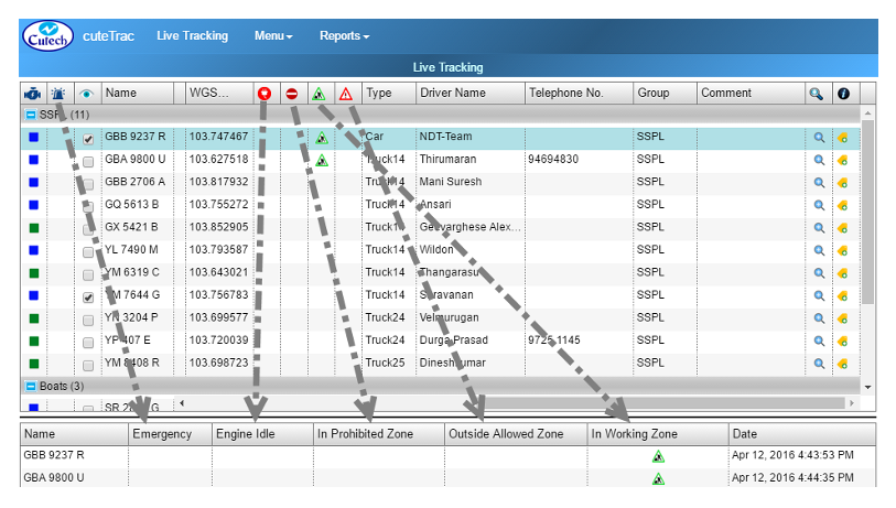
 -The second column of the “Live Tracking” window shows for Emergency alert. If an alert button is provided in the vehicle, user can press and activate it. When the user have pressed the emergency alert button it will be shown in the bottom of the “Live Tracking” window. Also, alert message will send to a corresponding person`s email ID and configured phone numbers.
 - Visible Status
 -The third column shows for setting Visible status of the vehicle. For each vehicle there will be check box provided in the “Live Tracking” window. If the check box is ticked, the vehicle will appear in the map; when the check box has unticked, the vehicle will disappear from the map. Note: when the user logout from the application and login again, vehicle visibility retrieves the same what have been done before.
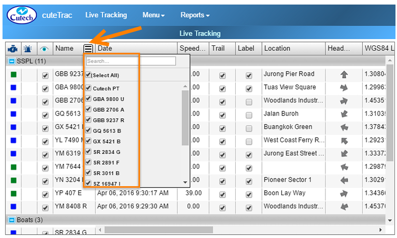
- Name column- Name column shows the name of all vehicles that are grouped under corresponding vehicle groups. Search and filter option is provided see button
 . This search and filter feature are applicable also in the following
columns of, “Date, Location, Heading, Vehicle Type, Driver Name, Telephone No., Vehicle Group, and Comment”.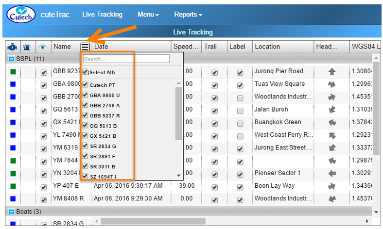
- To find a specific vehicle name you want, type the vehicle name in Search box.
- To filter a specific vehicle name you want, mark the check box provided for each vehicle.
- Date column- Shows the last known date/time of the vehicle. It will always shows the latest timing. Search and filter option is provided.
- Speed column- Displays travelling speed of vehicle in kilometer per hour, even when the vehicle engine is off. When the vehicle travels more than the limited speed, alert message will send to a corresponding person`s email ID. Also it will show in the bottom of “Live Tracking” window.
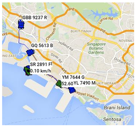
- Trail column- Displays the recent vehicle movement trail for the configured duration with maximum of 99 minutes. Each trail column has provided with a check box corresponding to the vehicle name. When the check box has clicked, that will show the recent vehicle movement.
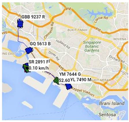
- Label column- Shows the name of the vehicle on the map along with the speed when engine is on, when the checkbox corresponding to the vehicle is checked. Note: even if you have logout from the application and login again, label feature retrieves the same what you have done before.
- Location column- Shows the location such as road name of the vehicle. Search and filter option is provided.
- Heading column- Shows the direction of the vehicle where it travels. Search and filter option is provided.
- WGS84 Latitude: Shows vehicle latitude in WGS Coordinate system.
- WGS84 Longitude: Shows vehicle longitude in WGS Coordinate system.
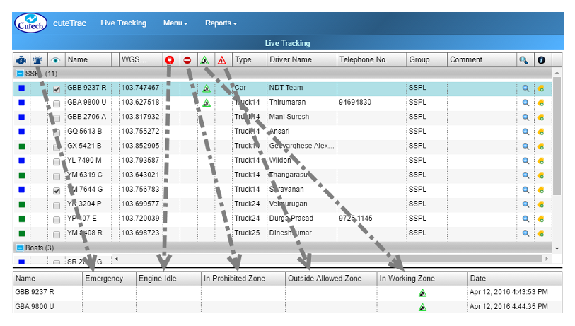
- Vehicle Alerts
-
 Shows if the vehicle that engine is idle for 10 minutes or more, so that message alert will be sent to a corresponding person`s email ID. Also it is shown at the bottom of the “Live Tracking” window. Refer to the above screenshot.
  Shows if the vehicle enters into a prohibited zone, so that message alert will send to a corresponding person`s email ID. Also it is shown at the bottom of the “Live Tracking” window. Refer to the above screenshot.
 Shows the vehicle in a working zone, so that message alert will send to a corresponding person`s email ID. Also it is shown at the bottom of the “Live Tracking” window. Refer to the above screenshot.
 Shows the vehicle in an outside allowed zone, so that message alert will send to a corresponding person. Also it is shown at the bottom of the “Live Tracking” window. Refer to the above screenshot.
-
- Type column-Shows the type of vehicle, where the vehicle type will be Car, Truck, Boat and Asset. Search and filter option is provided.
- Driver Name column-Lists the name of the driver driving the vehicle. Search and filter option is provided.
- Telephone No. column- Shows the contact number of the driver driving the vehicle. Search and filter option is provided.
- Group column- Displays the vehicle group name consisting list of vehicles together. Search and filter option is provided.
- Comment: Helps keeping the feedback for easy reference. Search and filter option is provided.
 -Helps zooming the map and just click on the button to zoom in.
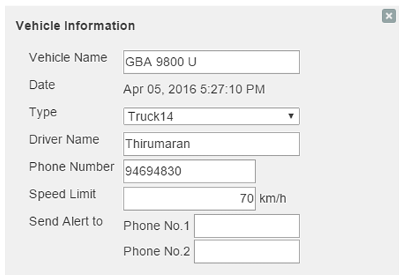
 column- Includes edit option
  in the column, help maintaining data of Vehicle Type, Driver
Name and Telephone Number. To maintain the vehicle details,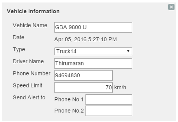
1. Navigate to the vehicle you want to make changes, and click onedit button. A new “Vehicle Information” window appears.
2. Add details you want. Note: If you have changed the “Vehicle Type” in Vehicle Information, the new vehicle`s symbol appears in the map instead of the old vehicle`s symbol.
- Immobilize- Allows vehicle supervisors to stop and immobilize the vehicle in their remote area. The vehicle needs to be mobilized again in order for the vehicle to be able to be stopped. To enable this feature, a specialized device need to be installed in vehicles.
-
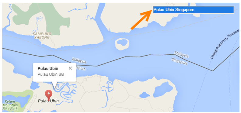
Search Location- If you want to search a specific location from the map, go to “Search Location” box provided in the top right corner of the screen. Type the location you want to search. See below screenshot as example,
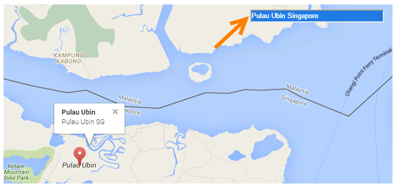
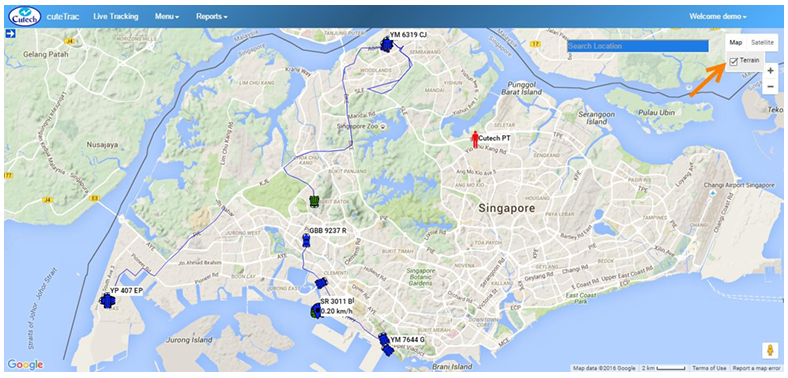
- Terrain View - If you want to view the map in terrain form,
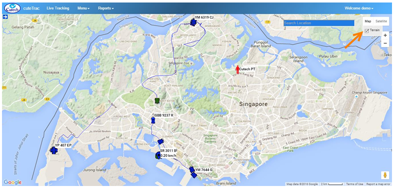
1. Navigate to the top right side of the screen, and click Map. Terrain option appears with a check box.
2. Mark the check box. The map will appear in terrain form.






- Satellite View - If you want to view the map in satellite form,
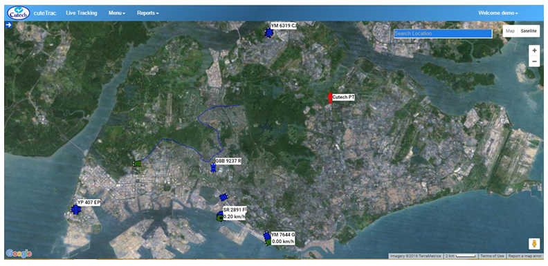
1. Navigate to the top right side of the screen, and click Satellite.
2. The map will appear in satellite form.
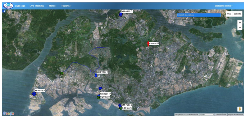
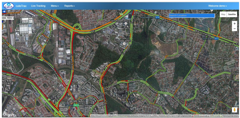
- Label View- If you want to view the map with the roads and labels,
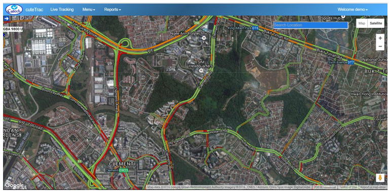
1. Navigate to the top right side of the screen, and click and click Satellite. Label option appears with a check box.
2. Mark the check box. The map will appear as below with overlay of the roads and labels.
Menu-Playback, Zone, Options, Vehicle Groups, Group Visibility, Email, Expenses, Reminders, Others
Playback
Playback option helps checking tracked vehicle's history data. One year data will be kept in the server for playback purposes. It will show data such as “Time, Vehicle Speed, Engine Status, Vehicle Latitude, Vehicle Longitude, Heading, Engine Idle Status, In Prohibited Zone, In Working Zone, and Outside Allowed Zone”. 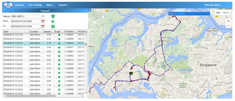 To playback the historic vehicle data,
1. Navigate to the Menu tab provided in the top left side of the screen, and click on it. List of menu items appear.
2. Click Playback in menu items. Playback page appears.
3. Select a Vehicle you want to search from the drop-down list box.
4. Select the dates you want to search for the vehicle data in From and To. A maximum of 24 hours data can be replayed at any one time.
5. Click  “Load Playback Data” button . The selected vehicle data appears.
6. Use the down arrow to see and playback in a faster fashion. Note: Once you have clicked button , the start playback button  and excel import
  options will appear.
- Start Playback
 - To view the vehicle movement for the dates you have selected, click this automatic playback button. So that the vehicle movement will appear in the map automatically. You can also use the use the keyboard`s up and down arrow icons to find the vehicle movements in for.
 - Export to Excel
 - To export the vehicle data in excel form, click the excel import button.
Kindly refer the below YouTube video for reference
https://www.youtube.com/watch?v=4Nb4ITbaGiQ
Zone (Geofence)
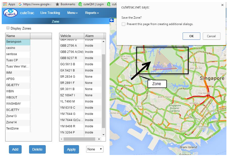
In cuteTrac, three difference type of zones can be created to assign to the vehicle, such as Inside (Prohibited Zone Alert), Outside (Leaving Allowed Zone Alert) and Working Zone. So that a corresponding person will get a vehicle alert message as per vehicle`s movement.
To create a new zone,
- Navigate to the Menu tab provided in the top left side of the screen, and click on it. List of menu items will appear.
- Click Zone in menu items. Zone page appears.
- Plan the Zone you want to create from the map.
- Click Add button provided in left side of the screen at the bottom of the “Live Tracking” window.
- Navigate to the map and click on the first point you want to create, using your mouse.
- Move to the next point and click on it. Repeat the same action until you close the zone you want to create.
- Once you have created the zone you want, you have to close it by either of the following two ways,
- If you work in Google Chrome, right click the mouse, so the system will show the following alert message of, “Save the Zone?” Click OK. The Zone will close.
- If you work in Internet Explorer, move you mouse outside the zone you have created. Double-click it using the mouse. The Zone will close.
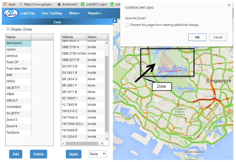
- The newly created zone name displays in the “Live Tracking” window at the left side of the screen.
- To rename the zone, click on the zone and it turns into editable. Rename the zone as you want.
- So, once you have created the zone you can apply it for the vehicles listed in the right side of the “Live Tracking” window.
- Select the area you want to set whether Inside (Prohibited Zone Alert) or Outside (Leaving Allowed Zone Alert) or None from drop-down list at the bottom of the “Live Tracking” window, so that the alert condition will set.
- Click Apply. If you have set alert for “Inside”, alert message will come when the selected vehicle enters into the prohibited zone. When you have set alert for “Outside”, alert message will come when the selected vehicle moves outside of the zone. If you select as “None”, it will remove existing relationship between zones and vehicles.
- Working zone checkbox is made available only for certain users with a specific need of requiring to configure regular drop off points island wide such as NTUC outlets etc. This option will keep track of the regular visits and helps to be
generate the reports.
Delete Zone
You can also delete the existing zone, when you want. To delete the existing zone,
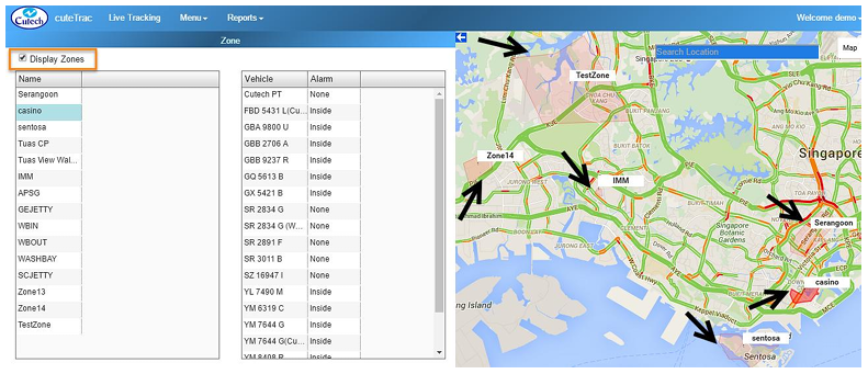
Display Zones
cuteTrac allows you to view all the created zones at a sometime, so you have to go “Display Zones” given in the top left corner of the screen, and mark the check box.
Options
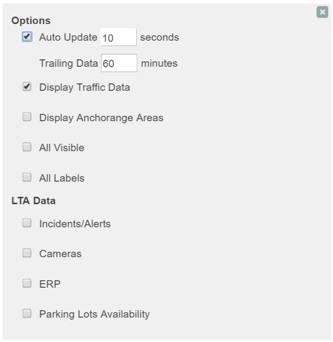
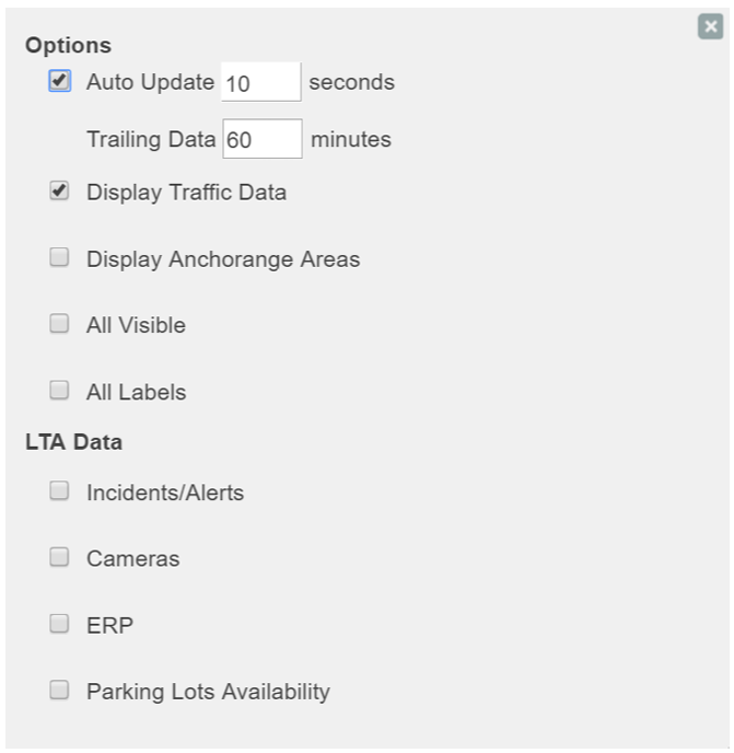
Options allows users to set activity data of live tracking. To update the options level,
- Navigate to the Menu tab provided in the top left side of the screen, and click on it. List of menu items will appear.
- Click Options in menu items. Options List appears.
- Set the page for your requirement.
- Auto Update: Allows you to set time period for automatic updating of live data that fetch from cuteTrac Server and show it on the map. Default time period is 10 seconds.
- Trailing Data: Allows you to set time period for getting trail data from the map. Default time is 30 minutes. It can be set up to maximum of 99 minutes.
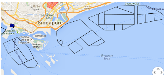
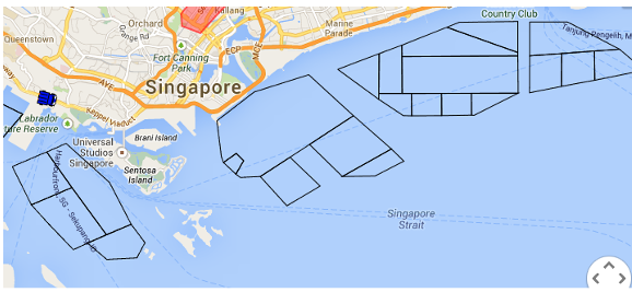
- Display Anchorage Zones: This will show the anchorage zones of Singapore that is available only for Boats.
- All Visible: This option used to turn on visible flag for all the vehicle and shows at the map to follow it closely.
- All Labels: This option used to keep the vehicle`s name displayed in the map.
- LTA Data: The LTA data such as current incident/accidents, cameras, ERP Locations and Parking lot availability.
Vehicle Groups
Vehicle Group helps to manage vehicles in groups for easier viewing at the live tracking window. To create a new vehicle group,
Rename Vehicle Group
User can rename a vehicle group name. To rename the group, 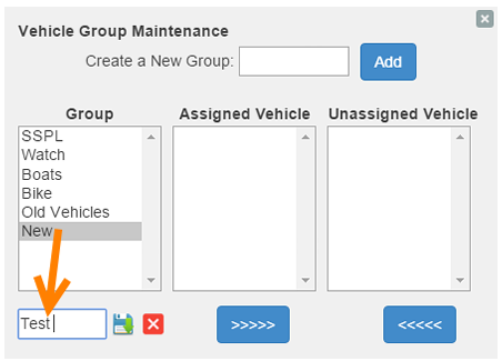
- Select the vehicle group you want to rename.
- Type a new name of vehicle group in a text box given under the “Group” column.
- Click the
 “Save” button.

Assign Vehicle
Once the vehicle group is created, you can assign the vehicle under corresponding vehicle groups. To assign the vehicle,
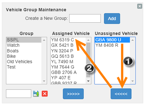
- Select the group name under “Group” and vehicle under “Unassigned Vehicle”,
- Click
 button, so the selected vehicle will come under Assigned Vehicle corresponding to the group you have selected.
 - Click the “Save” button to save the changes.

Remove Vehicle from Group
User can remove vehicle from vehicle group, to remove vehicle from a group,
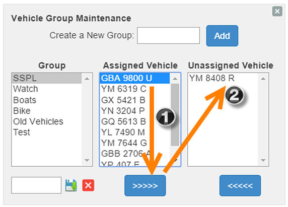
- Select the group name under “Group” and vehicle under “Assigned Vehicle”,
- Click
 button, so the vehicle will come under Unassigned Vehicle corresponding to the group you have selected.
 - Click the “Save” button to save the changes.

Delete Vehicle Group
To delete a particular vehicle group,
- Select the vehicle group or the vehicle comes under a vehicle group, you want to delete.
- Click
 delete button.
 - System will display a new message of, “Confirm you want to delete!”.
- Click OK to confirm deletion.

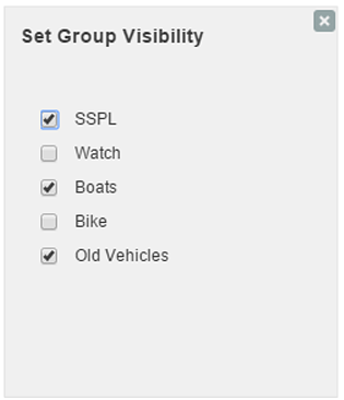
Group Visibility
Group Visibility means setting visibility of vehicle groups in live tracking of the system. To set vehicle groups visibility,
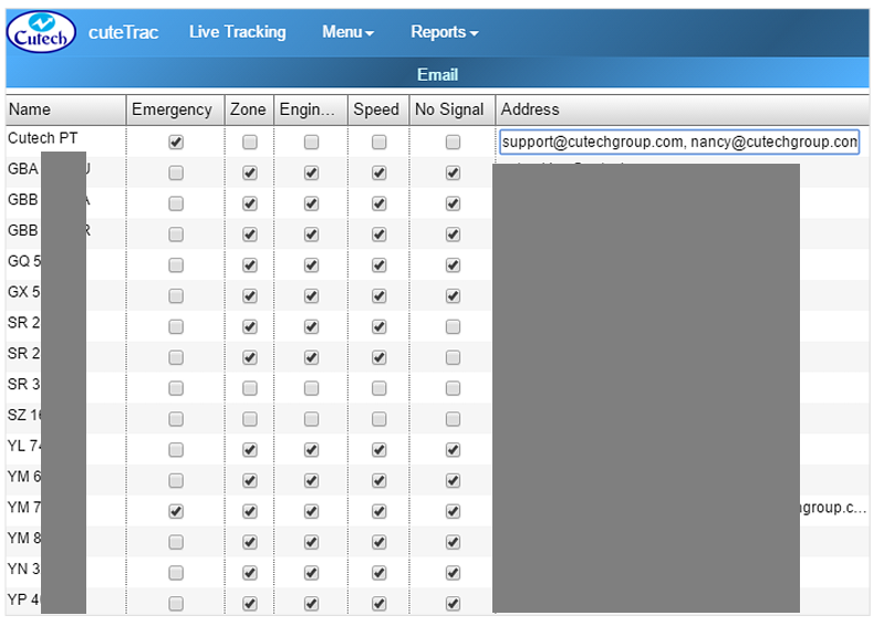
cuteTrac ensures sending alert messages to a corresponding person in following five scenarios by setting access privileges ,
- Emergency Alert
- Zone Violation
- Engine Idle State
- Over Speed
- No Signal
Emergency Alert - In each vehicle, there is one emergency alert button used by vehicle drivers when they are in emergency. The vehicle driver have to simply press the emergency alert button, so that a corresponding person will receive email alert.
Zone Violation - In cuteTrac each vehicle should travel in a specific zone that has applied to the vehicle. So there are three types of alerts applicable in the zone, when the vehicle enters into a prohibited area, when the vehicle leaving from the zone, and when the vehicle in a working zone.
Engine Idle State - Alert message should send to a corresponding person, when the vehicle`s engine idle for a long time (more than 10 minutes).
Over Speed - cuteTrac has the set speed limit for each vehicle and the alert message has to be sent when the vehicle crossed the limit.
No Signal - Alert message should send to a corresponding person, when signal has not received from the vehicle.
Set Email Access Privileges
To set access privileges,
Others
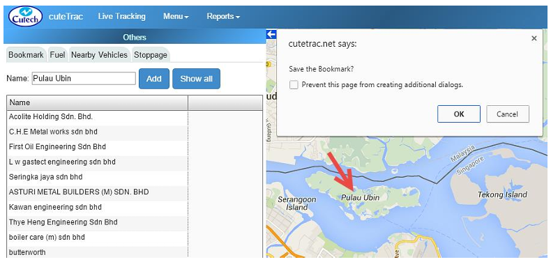
Others option tab consists of adding additional details of, “Bookmark, Fuel Details, Nearby Vehicles, and Stoppage Duration”.
Bookmark
In cuteTrac, you can add “Bookmark” in the map wherever you want. To add the Bookmark,
Fuel Details
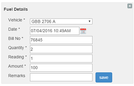
In cuteTrac, each vehicle should updated with fuel details.
Add Fuel Details
To add for fuel details,
View Fuel Details
To view the added fuel details,
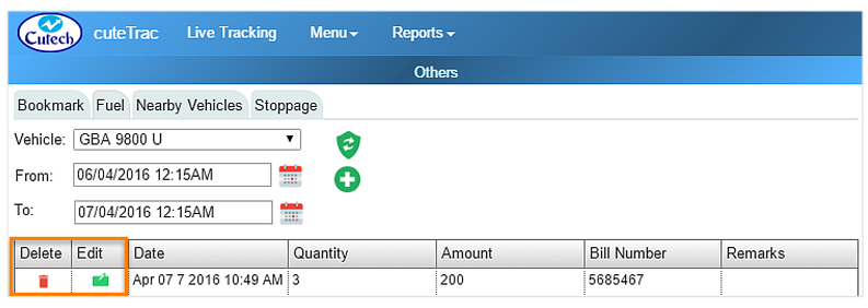
- Select the Vehicle and From and To dates.
- Click this
 “Load Fuel Details” button .
 - You can also edit and delete the existing fuel details using “Edit and Delete” options shown in the above figure.

Nearby Vehicles
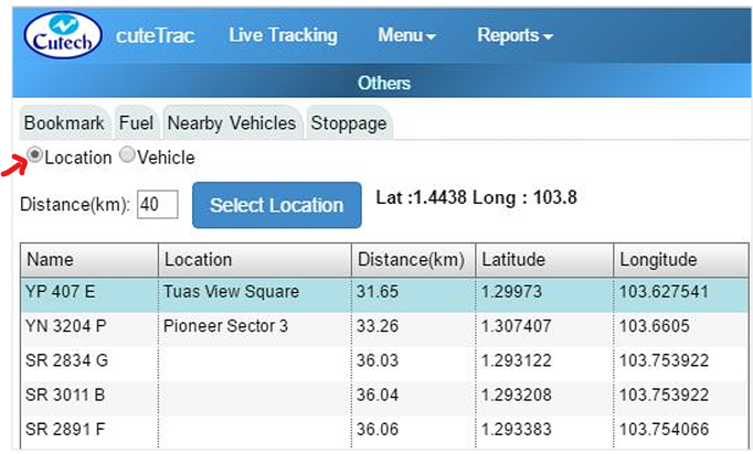
In cuteTrack, you can search for vehicles travel nearby you. You can search it by two options, one is “Location” and the other is “Vehicle”.
To search the nearby vehicle by location,
To search the nearby vehicle by vehicle name,
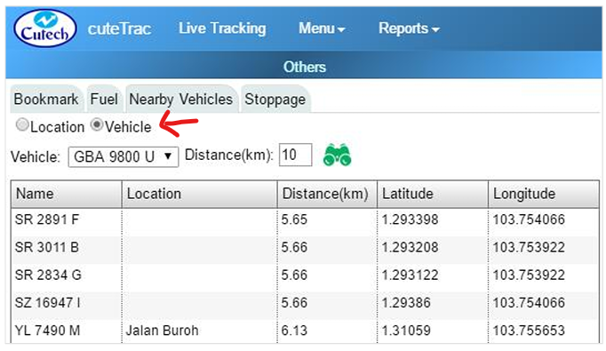
- Navigate to the Menu tab provided in the top left side of the screen, and click on it. List of menu items will appear.
- Click Others in menu items. Others window appears.
- Click Nearby Vehicles.
- Choose Vehicle.
- Select the name of Vehicle you want to search from the drop-down list.
- Enter the Distance in kilometer.
- Click this
 “Find” button.

Stoppage
Stoppage allows you to check how many times the vehicle has stopped for a day at specific time. To check for stoppage of the vehicle,
- Navigate to the Menu tab provided in the top left side of the screen, and click on it. List of menu items will appear.
- Click Stoppage in menu items. Stoppage window appears.
- Select the Vehicle from the drop-down list.
- Mention the Duration of stoppage.
- Select the From and To dates and time you want to check for stoppage of the vehicle.
- Click this “Submit” button.
Legend
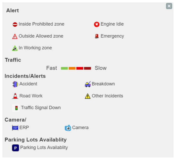
Legend shows the icon and their meanings of, Inside Prohibited Zone, Outside Allowed Zone, In Working Zone, Engine Idle and Emergency. Also it shows the traffic level, where green indicates less traffic and brown indicates more traffic.
Reports
cuteTrac application includes multiple reports that contains particular data and activity result. Those reports will be the collection of activity data processed in cuteTrac application. You can filter the report data for particular date(s), vehicle type, vehicle, time zone, coordination system, distance units, speed units, and options. The reports includes daily working status, daily engine status, daily alert status, vehicle`s daily speed graph, vehicle position data, daily summary, monthly summary based on vehicle, monthly summary based on day, unutilized vehicles, working zone entry, and travelled roads.
Working Status
This report provides travelling data of a vehicle for a specific date you want. Also you have filtering options for, Vehicle Type (Car, Boat, Truck and Asset), Vehicle (All vehicles), Time Zone (Local and UTC), Coordinate System (Local and WGS84), Distance Units (Kilometers, Miles, Nautical Miles), Speed Units (Kilometer per hour, Miles per hour, and Knots), and Options (Road Name and
Coordinates).
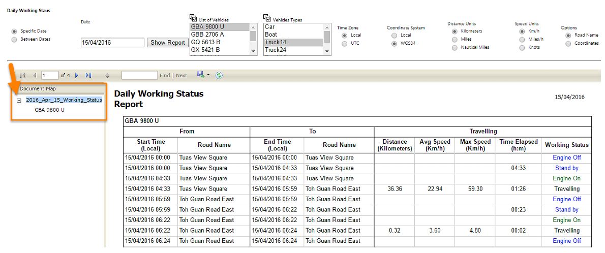
This working status shows vehicle start time, name of the road that vehicle started to travel, stop time, name of the road that vehicle stopped the travel, travel distance, average travel speed, maximum travel speed, total time taken for travel, and working status. There are four working stratus as follow, “Engine On, Stand by, Travelling and Engine Off”.
To check daily working status of the vehicle,
- Navigate to the Reports tab provided in the top left side of the screen, and click on it. List of menu items appears.
- Click Working Status in menu items. Report will open in new window. In the new window itself, all of other report options appear.
- Search options appear at the top of the screen.
- Select the date you want to search for working status. You can check the working status for a specific date, and also for more than a day. So choose either Specific Date or Between Dates and add for date(s) you want.
- Select a Vehicle Type, and Vehicle you want to search.
- Set the “Time Zone, Coordination System, Distance Units, Speed Units, and Options”.
- Click Show Report. The specific vehicle you have filtered shows in the document map at the left side of the screen. You can collapse or expand the document map using these buttons, such as
 and
and , respectively, as shown in below screenshot,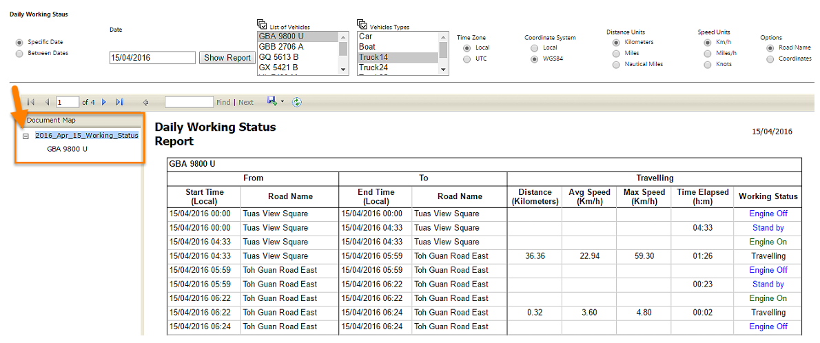


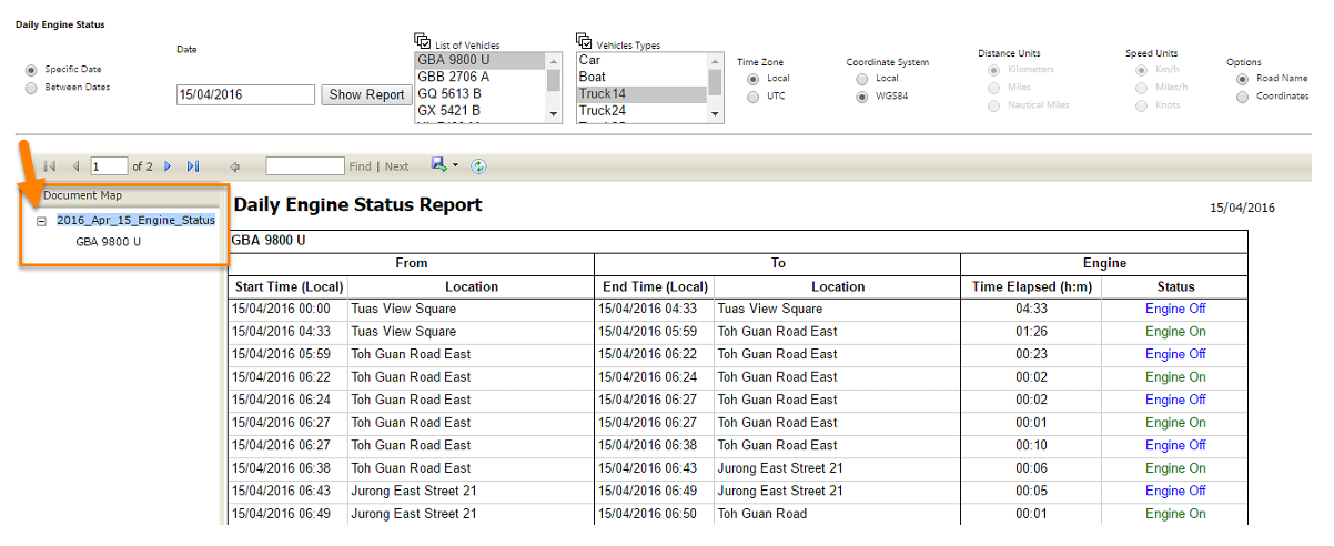
Engine Status
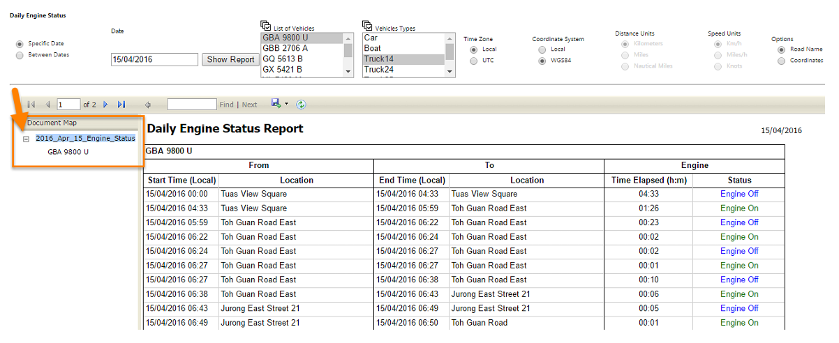
This report shows the engine status of the vehicle, when the engine has on and engine has off. You can search and filer the following data to view the engine status of a vehicle, such as Date, Vehicle Group, Vehicle, Time Zone (Local and UTS), Coordinate System (Local and WGS84), and Options (Road Name and Coordinates).
This report shows engine status when the vehicle starts travelling and when the vehicle ends travelling along with travel location and total travel time takes.
To check daily engine status of the vehicle,
- Navigate to the Reports tab provided in the top left side of the screen, and click on it. List of menu items will appear.
- Click Engine Status in menu items. Report will open in new window. In the new window itself, all of other report options appear.
- Search options appear at the top of the screen.
- Select the date you want to search for working status. You can check the working status for a specific date, and also for more than a day. So choose either Specific Date or Between Dates and add for date(s) you want.
- Select a Vehicle Type, and Vehicle you want to search.
- Set the “Time Zone, Coordination System, and Options”.
- Click Show Report. The specific vehicle you have filtered shows in the document map at the left side of the screen. You can collapse or expand the document map using these buttons, such as and, respectively.
Alert Status
To check daily engine status of the vehicle,
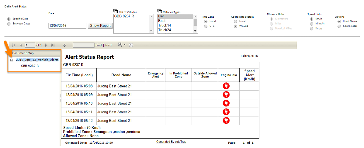
Daily Alert Status
In cuteTrac, there will be a feature of sending alert message at specific conditions so that the vehicles can be tracked effectively. Alerts varies as follow, Emergency Alert, In Prohibited Zone, Outside Allowed Zone, and Engine Idle.
Emergency Alert - In each vehicle, there is one emergency alert button provided for vehicle drivers when they are in emergency. So the list of given emergency alerts given from the vehicles listed in this report status.
In Prohibited Zone - Shows the list of vehicles enters into the prohibited area.
Outside Allowed Zone - Shows the list of vehicles comes out of the allowed area.
Engine Idle - Shows the list of vehicle that engine has idle for a long time even the engine has on.
To check for daily alert status,
- Click All Alerts Report under Alert Status.
- Search options appear at the top of the screen.
- Select the date you want to search for working status. You can check the working status for a specific date, and also for more than a day. So choose either Specific Date or Between Dates and add for date(s) you want.
- Select a Vehicle Type, and Vehicle you want to search.
- Set the “Time Zone, Coordination System, Speed Units, and Options”.
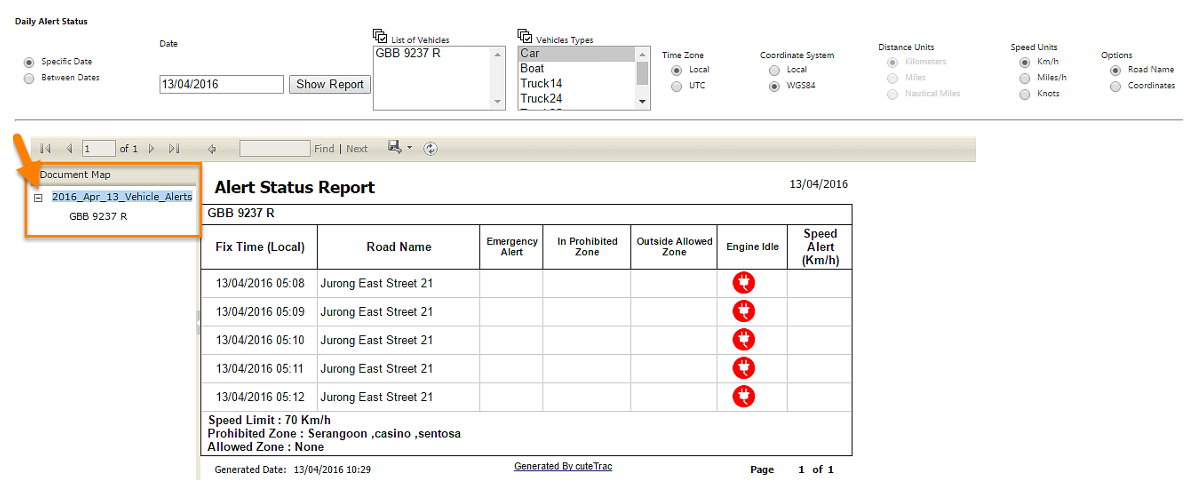
- Click Show Report. The specific vehicle you have filtered shows in the document map at the left side of the screen. You can collapse or expand the document map using these buttons, such as and, respectively.
Engine Idling Report
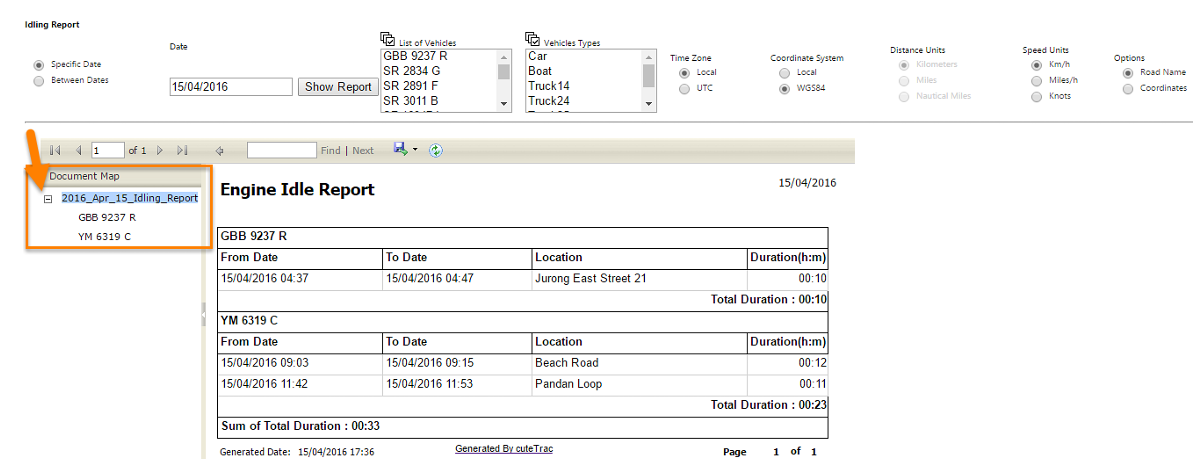
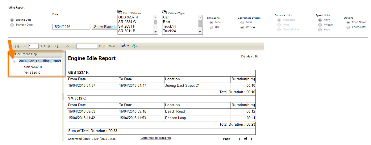
This report accurately shows where and when the engine has idle along with a time duration.
To check for engine idling status,
- Click Engine Idling Report under Alert Status.
- Search options appear at the top of the screen.
- Select the date you want to search for working status. You can check the working status for a specific date, and also for more than a day. So choose either Specific Date or Between Dates and add for date(s) you want.
- Select a Vehicle Type, and Vehicle you want to search.
- Set the “Time Zone, Coordination System, Speed Units, and Options”.
- The specific vehicle you have filtered shows in the document map at the left side of the screen. You can collapse or expand the document map using these buttons, such as and, respectively.
Zone Violation Report
This report shows the list of vehicles that has entered into the prohibited zone or leaving from the allowed zone.
To check for zone violation report,
- Click Zone Violation Report under Alert Status.
- Search options appear at the top of the screen.
- Select the date you want to search for working status. You can check the working status for a specific date, and also for more than a day. So choose either Specific Date or Between Dates and add for date(s) you want.
- Select a Vehicle Type, and Vehicle you want to search.
- Set the “Time Zone, Coordination System, Speed Units, and Options”.
- Click Show Report.
Speed Graph
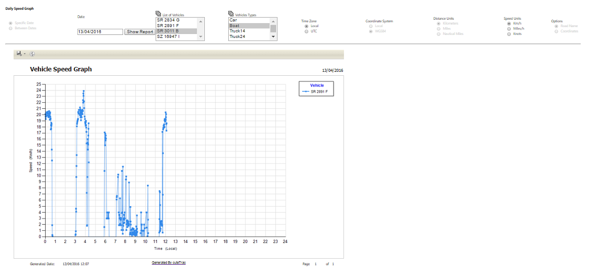
This report shows the speed of vehicle(s) in a graph form. In this speed graph you have only two filter options, such as Time and Speed. The Time has shown in Xaxis, and Speed has shown in Y-axis.
To check daily speed graph of the vehicle,
- Navigate to the Reports tab provided in the top left side of the screen, and click on it. List of menu items will appear.
- Click Speed Graph in menu items. Report will open in new window. In the new window itself, all of other report options appear.
- Search options appear at the top of the screen. Date appears in default.
- Select a Vehicle Type, and Vehicle you want to search.
- Set the “Time Zone, and Speed Units”.
- Click Show Report. The specific vehicle you have filtered shows in the document map at the left side of the screen. You can collapse or expand the document map using these buttons, such as and, respectively.
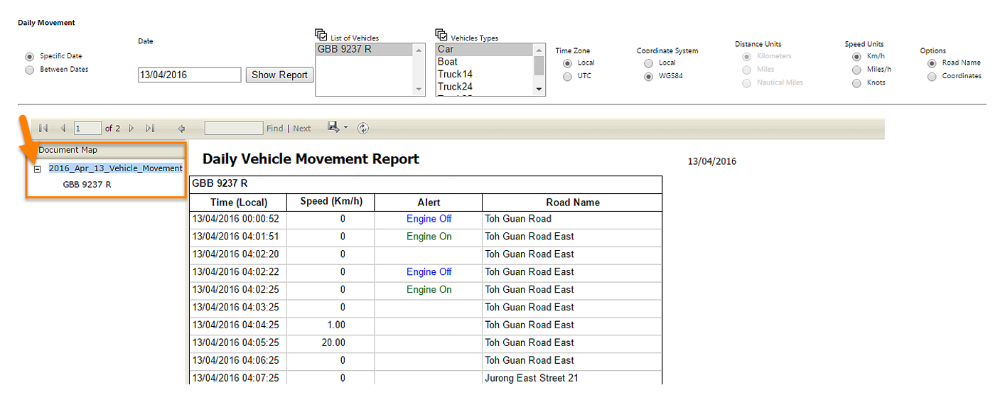
Position Data
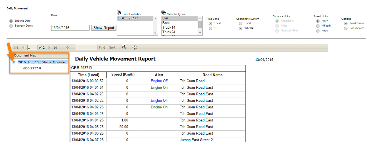
This report shows exact movement of the vehicle for the specific date(s) you have selected. You can search and filer the following data to view the engine status of a vehicle, such as Date, Vehicle Group, Vehicle, Time Zone (Local and UTS), Coordinate System (Local and WGS84), Speed Units (Kilometer per hour, Miles per hour, and Knots) and Options (Road Name and Coordinates).
To check the movement of the vehicle,
- Navigate to the Reports tab provided in the top left side of the screen, and click on it. List of menu items will appear.
- Click Position Data in menu items. Report will open in new window. In the new window itself, all of other report options appear.
- Search options appear at the top of the screen.
- Select the date you want to search for working status. You can check the working status for a specific date, and also for more than a day. So choose either Specific Date or Between Dates and add for date(s) you want.
- Select a Vehicle Type, and Vehicle you want to search.
- Set the “Time Zone, Coordinate System, Speed Units, and Options”.
- Click Show Report. The specific vehicle you have filtered shows in the document map at the left side of the screen. You can collapse or expand the document map using these buttons, such as and, respectively.
Daily Summary
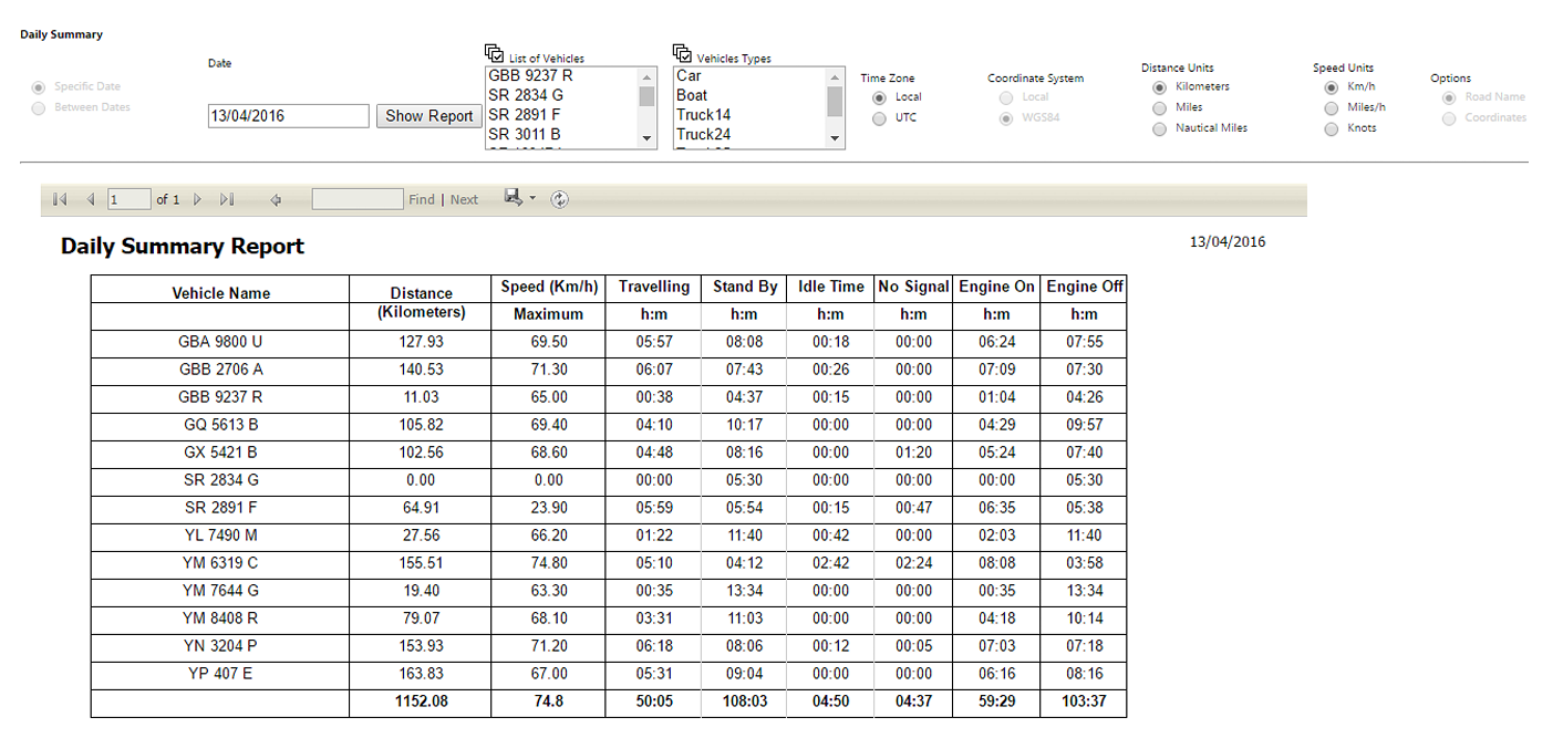
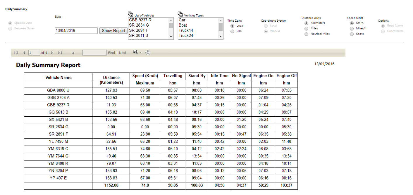
To check daily summary of the vehicle,
- Navigate to the Reports tab provided in the top left side of the screen, and click on it. List of menu items will appear.
- Click Daily Summary in menu items. Report will open in new window. In the new window itself, all of other report options appear.
- Search options appear at the top of the screen. Date appears in default.
- Select a Vehicle Type, and Vehicle you want to search.
- Set the “Time Zone, Coordinate System, Distance Units, Speed Units, and Options”.
- Click Show Report.
Monthly Summary by Vehicle
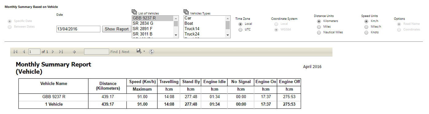
To check monthly summary of the vehicle,
- Navigate to the Reports tab provided in the top left side of the screen, and click on it. List of menu items will appear.
- Click Summary (Vehicle) in menu items. Report will open in new window. In the new window itself, all of other report options appear.
- Search options appear at the top of the screen. Date appears in default.
- Select a Vehicle Type, and Vehicle you want to search.
- Set the “Time Zone, Coordinate System, Distance Units, and Speed Units.
- Click Show Report.

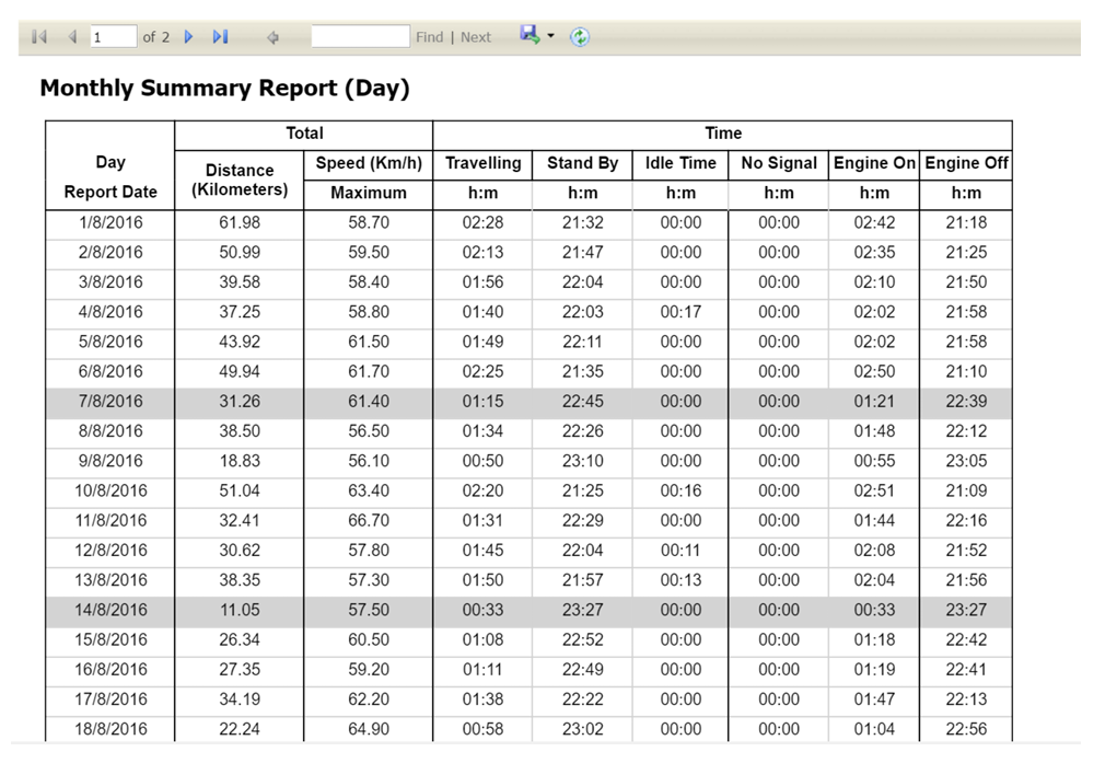
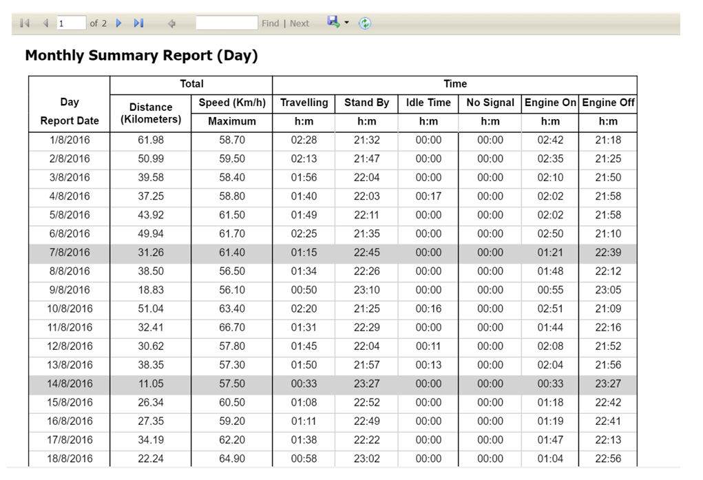
Monthly Summary by Day
To check daily summary of the vehicle,
- Navigate to the Reports tab provided in the top left side of the screen, and click on it. List of menu items will appear.
- Click Summary (Day) in menu items. Report will open in new window. In the new window itself, all of other report options appear.
- Search options appear at the top of the screen. Date appears in default.
- Select a Vehicle Type, and Vehicle you want to search.
- Set the “Time Zone, Coordinate System, Distance Units, and Speed Units.
- Click Show Report.
Utilized Vehicles
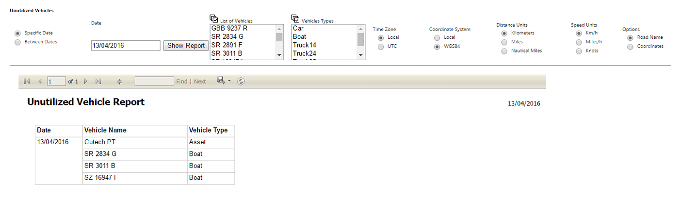
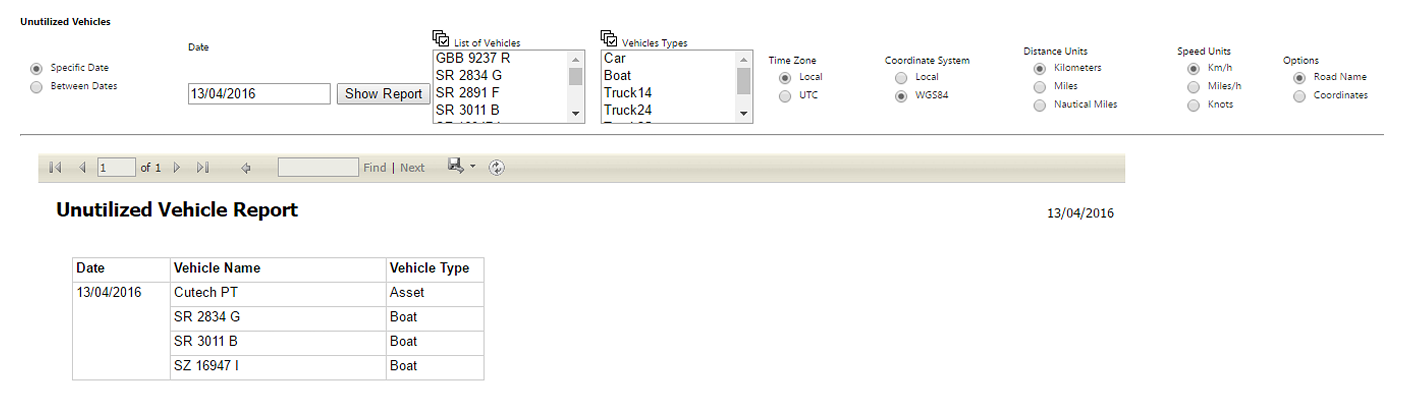
To check utilized vehicle,
- Navigate to the Reports tab provided in the top left side of the screen, and click on it. List of menu items will appear.
- Click Utilized Vehicle in menu items. Report will open in new window. In the new window itself, all of other report options appear.
- Search options appear at the top of the screen.
- Select the date you want to search for working status. You can check the working status for a specific date, and also for more than a day. So choose either Specific Date or Between Dates and add for date(s) you want.
- Select a Vehicle Type, and Vehicle you want to search.
- Set the “Time Zone, Coordinate System, Distance Units, Speed Units, and Options.
- Click Show Report.
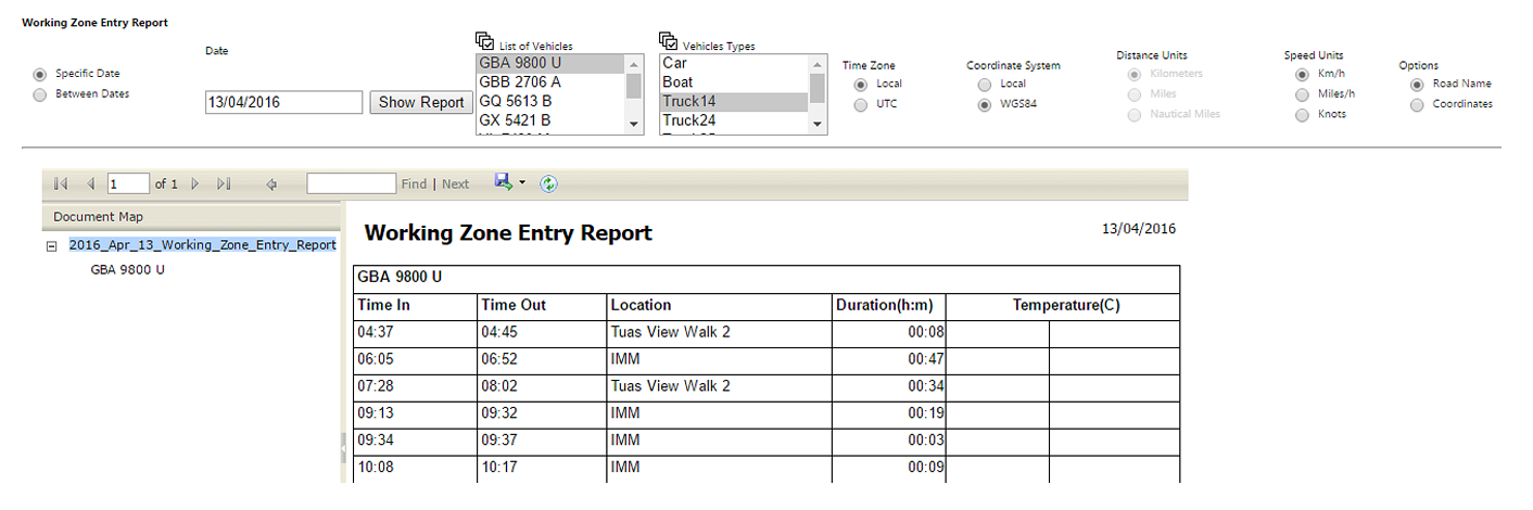
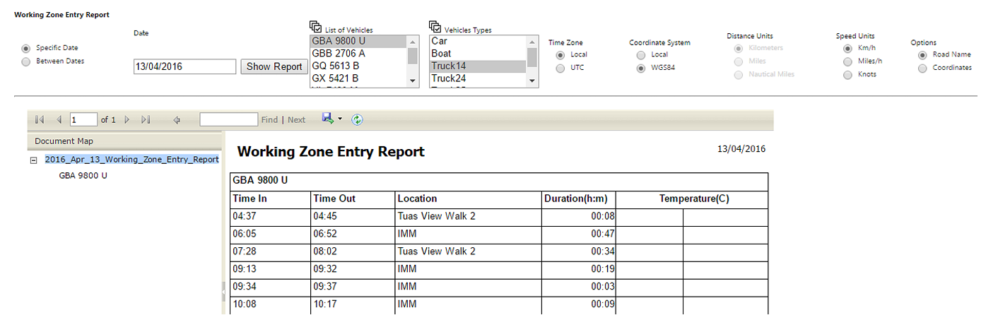
Working Zone Entry
To check working zone entry,
- Navigate to the Reports tab provided in the top left side of the screen, and click on it. List of menu items will appear.
- Click Working Zone Entry in menu items. Report will open in new window. In the new window itself, all of other report options appear.
- Search options appear at the top of the screen.
- Select the date you want to search for working status. You can check the working status for a specific date, and also for more than a day. So choose either Specific Date or Between Dates and add for date(s) you want.
- Select a Vehicle Type, and Vehicle you want to search.
- Set the “Time Zone, Coordinate System, Speed Units, and Options.
- Click Show Report.
Roads Travelled
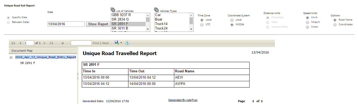
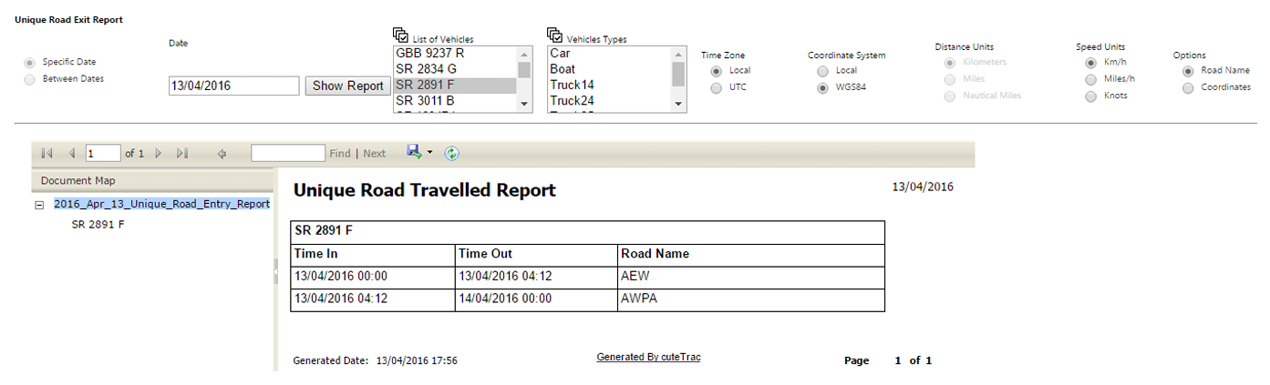
To check all the roads through which a vehicle has travelled,
- Navigate to the Reports tab provided in the top left side of the screen, and click on it. List of menu items will appear.
- Click Roads Travelled in menu items. Report will open in new window. In the new window itself, all of other report options appear.
- Search options appear at the top of the screen.
- Select the date you want to search for working status. You can check the working status for a specific date, and also for more than a day. So choose either Specific Date or Between Dates and add for date(s) you want.
- Select a Vehicle Type, and Vehicle you want to search.
- Set the “Time Zone, Coordinate System, Speed Units, and Options.
- Click Show Report.
Export Reports
All the reports can be exported to PDF, Excel and Word format. Simply click on the Disk Icon as shown above and click the required format. The output will be generated and downloaded to the local machine.
Mobile Apps
The cuteTrac mobile App is available for both Android and iOS.
Search for cuteTrac in play store / App store to download and install the App.
Android Phone:
https://play.google.com/store/apps/details?id=com.cutetrac
iOS:
https://apps.apple.com/sg/app/cutetrac/id997646453
Login:
Use the same username and password used to login in the web.
API
cuteTrac Vehicle Position API
cuteTrac Vehicle Position API
Developer Integration Guide
API Name: Vehicle Position API
Purpose: Retrieve the latest GPS position and vehicle status information for vehicles registered in the cuteTrac fleet management system.
1. API Endpoint
Production Endpoint
GET https://www.cutetrac.com/api/cuteTracAPIServicePUB.svc/positionRequest URL
https://www.cutetrac.com/api/cuteTracAPIServicePUB.svc/position?key={API_KEY}&fmt=jsonHTTP Method
GETResponse Format
JSON2. Authentication
The API requires an API key to authenticate the request.
Query Parameters
| Parameter | Required | Description | Example |
|---|---|---|---|
key |
Yes | API authentication key issued by cuteTrac | ABC123XYZ |
fmt |
Yes | Response format | json |
Example Request
GET https://www.cutetrac.com/api/cuteTracAPIServicePUB.svc/position?key=YOUR_API_KEY&fmt=jsonSecurity: The API key should be treated as confidential. Do not expose the API key in publicly accessible client-side JavaScript, mobile applications, or source code repositories. Where possible, make API calls through your application's backend/server.
3. Response
The API returns a JSON array containing the latest position information for vehicles.
Example Response
[
  {
    "AddressLocation": "187 Pandan Loop",
    "Asset": "YR 4548 U (Raja)",
    "AssetID": "163",
    "Battery": "0",
    "Course": "254.00",
    "DriverName": "",
    "DriverTel": "",
    "Fix": "GPS Fix",
    "FixID": "2",
    "Fuel": "0",
    "HDOP": "0",
    "Ignition": "0",
    "Mileage": "152253.11251000",
    "PosID": null,
    "PosX": "103.7536033000",
    "PosY": "1.3118916000",
    "PosZ": "0",
    "RxTime": "2026-09-09T13:57:28.000",
    "Satellites": "14",
    "Speed": "0.00",
    "Timestamp": "2026-09-09T13:57:28.000",
    "VehicleGrp": ""
  }
]
Each object in the returned array represents one vehicle/asset.
4. Response Fields
| Field | Data Type | Description |
|---|---|---|
AddressLocation |
String | Approximate/current address or location of the vehicle |
Asset |
String | Vehicle registration number and associated driver/name, where configured |
AssetID |
String | Unique cuteTrac asset/vehicle ID |
Battery |
String/Number | Battery-related value reported by the tracking device |
Course |
String/Number | Direction of travel in degrees |
DriverName |
String | Driver assigned to the vehicle |
DriverTel |
String | Driver telephone number, if configured |
Fix |
String | GPS fix status |
FixID |
String/Number | Numeric GPS fix status identifier |
Fuel |
String/Number | Fuel value reported by the vehicle/device, where supported |
HDOP |
String/Number | Horizontal Dilution of Precision (GPS accuracy indicator) |
Ignition |
String/Number | Vehicle ignition status |
Mileage |
String/Number | Vehicle accumulated mileage |
PosID |
String/Number/Null | Position record identifier, if available |
PosX |
String/Number | Longitude |
PosY |
String/Number | Latitude |
PosZ |
String/Number | Altitude/elevation |
RxTime |
DateTime | Time the position data was received by the system |
Satellites |
String/Number | Number of GPS satellites detected |
Speed |
String/Number | Current vehicle speed |
Timestamp |
DateTime | Timestamp associated with the GPS position |
VehicleGrp |
String | Vehicle group assigned to the asset |
5. Important GPS Fields
The following fields are particularly useful when integrating cuteTrac with another application.
Latitude
PosYExample:
"PosY": "1.3118916000"Longitude
PosXExample:
"PosX": "103.7536033000"Therefore, the GPS coordinate is:
Latitude  = 1.3118916000
Longitude = 103.7536033000
These coordinates can be used with mapping platforms such as Google Maps, OpenStreetMap, or other mapping APIs.
6. Vehicle Speed
The Speed field represents the current vehicle speed.
Example:
"Speed": "0.00"A value of:
0.00indicates that the vehicle is currently stationary according to the latest GPS position.
Note: The unit of speed should be confirmed according to the specific cuteTrac account/device configuration before displaying or converting the value in another application.
7. Vehicle Ignition
The Ignition field indicates the ignition status reported by the tracking device.
Example:
"Ignition": "0"The application developer should use the agreed cuteTrac ignition status mapping when displaying this information.
For example, depending on the device configuration:
0 = OFF
1 = ON
The exact mapping should be confirmed with cuteTrac before implementing business logic based on this field.
8. Direction / Course
The Course field represents the vehicle's heading in degrees.
Example:
"Course": "254.00"The value is measured clockwise from North:
0°   = North
90°  = East
180° = South
270° = West
This value can be used to rotate a vehicle icon on a map to indicate the vehicle's direction of travel.
9. GPS Fix
The API provides GPS fix information through:
Fix
FixID
Example:
"Fix": "GPS Fix",
"FixID": "2"
Fix provides a descriptive status, while FixID provides the corresponding numeric identifier.
Applications should preferably use the Fix value for displaying the status and use FixID only when implementing status-based business logic.
10. Timestamp
The API provides two timestamp-related fields:
RxTime
Timestamp
Example:
"RxTime": "2026-09-09T13:57:28.000",
"Timestamp": "2026-09-09T13:57:28.000"
The values use the following general format:
YYYY-MM-DDTHH:mm:ss.fffExample:
2026-09-09T13:57:28.000Developers should parse these values as DateTime values rather than treating them as ordinary display strings.
11. Mileage
The Mileage field contains the accumulated mileage reported for the vehicle.
Example:
"Mileage": "152253.11251000"Applications should format the value appropriately for display.
For example:
152,253.11The unit of mileage should be confirmed according to the cuteTrac configuration before displaying the value as kilometres or miles.
12. Driver Information
The API can return driver information associated with the vehicle.
Example:
"DriverName": "Raja",
"DriverTel": "..."
However, these fields may be empty:
"DriverName": "",
"DriverTel": ""
Applications must therefore handle empty strings and should not assume driver information is always available.
13. Address Information
The AddressLocation field provides the current/last known address associated with the GPS position.
Example:
"AddressLocation": "187 Pandan Loop"The address can be displayed alongside the vehicle's location on a dashboard or vehicle tracking interface.
14. Multiple Vehicles
The API returns an array because multiple vehicles may be returned in a single request.
Example:
[
  {
    "Asset": "YR 4548 U (Raja)",
    "AssetID": "163",
    "PosX": "103.7536033000",
    "PosY": "1.3118916000",
    "Speed": "0.00"
  },
  {
    "Asset": "YR 6682 B (Ganesan)",
    "AssetID": "1706",
    "PosX": "103.7108416000",
    "PosY": "1.3351050000",
    "Speed": "0.00"
  }
]
The consuming application should iterate through the returned array and process each vehicle independently.
15. Example Integration Flow
A typical integration can follow this process:
1. Obtain API Key from cuteTrac
          |
          v
2. Send GET request to Position API
          |
          v
3. Receive JSON response
          |
          v
4. Parse JSON array
          |
          v
5. Process each vehicle
          |
          +--> Vehicle ID
          +--> Vehicle Registration
          +--> Driver
          +--> Latitude / Longitude
          +--> Speed
          +--> Ignition
          +--> Direction
          +--> Mileage
          +--> GPS Status
          |
          v
6. Display/store information in customer's application
16. Example JavaScript Request
const apiKey = "YOUR_API_KEY";

const url =
  `https://www.cutetrac.com/api/cuteTracAPIServicePUB.svc/position` +
  `?key=${encodeURIComponent(apiKey)}&fmt=json`;

fetch(url)
  .then(response => {
    if (!response.ok) {
      throw new Error(`HTTP Error: ${response.status}`);
    }

    return response.json();
  })
  .then(data => {
    data.forEach(vehicle => {
      console.log("Vehicle:", vehicle.Asset);
      console.log("Asset ID:", vehicle.AssetID);
      console.log("Latitude:", vehicle.PosY);
      console.log("Longitude:", vehicle.PosX);
      console.log("Speed:", vehicle.Speed);
      console.log("Ignition:", vehicle.Ignition);
      console.log("Timestamp:", vehicle.Timestamp);
    });
  })
  .catch(error => {
    console.error("cuteTrac API Error:", error);
  });
17. Example C# Integration
using System.Net.Http;
using System.Text.Json;

public async Task GetVehiclePositions(string apiKey)
{
    using var client = new HttpClient();

    string url =
        $"https://www.cutetrac.com/api/cuteTracAPIServicePUB.svc/position" +
        $"?key={Uri.EscapeDataString(apiKey)}&fmt=json";

    var response = await client.GetAsync(url);

    response.EnsureSuccessStatusCode();

    string json = await response.Content.ReadAsStringAsync();

    var vehicles = JsonSerializer.Deserialize<List<VehiclePosition>>(json);

    foreach (var vehicle in vehicles)
    {
        Console.WriteLine($"Vehicle: {vehicle.Asset}");
        Console.WriteLine($"Latitude: {vehicle.PosY}");
        Console.WriteLine($"Longitude: {vehicle.PosX}");
        Console.WriteLine($"Speed: {vehicle.Speed}");
    }
}
Example model:
public class VehiclePosition
{
    public string AddressLocation { get; set; }
    public string Asset { get; set; }
    public string AssetID { get; set; }
    public string Battery { get; set; }
    public string Course { get; set; }
    public string DriverName { get; set; }
    public string DriverTel { get; set; }
    public string Fix { get; set; }
    public string FixID { get; set; }
    public string Fuel { get; set; }
    public string HDOP { get; set; }
    public string Ignition { get; set; }
    public string Mileage { get; set; }
    public string PosID { get; set; }
    public string PosX { get; set; }
    public string PosY { get; set; }
    public string PosZ { get; set; }
    public string RxTime { get; set; }
    public string Satellites { get; set; }
    public string Speed { get; set; }
    public string Timestamp { get; set; }
    public string VehicleGrp { get; set; }
}
18. Mapping Integration Example
For a mapping application:
PosY = Latitude
PosX = Longitude
Course = Vehicle Heading
Speed = Vehicle Speed
Asset = Vehicle Display Name
AddressLocation = Current Address
For example:
Vehicle:
YR 4548 U (Raja)

Location:
Latitude:  1.3118916
Longitude: 103.7536033

Speed:
0.00

Direction:
254°

Address:
187 Pandan Loop
The consuming application can use PosX and PosY to place a vehicle marker on a digital map.
19. Handling Null and Empty Values
Developers must handle fields that may contain:
null
""
"0"
For example:
"PosID": null,
"DriverName": "",
"DriverTel": "",
"VehicleGrp": ""
The application should not assume that every field contains a value.
Recommended handling:
null       → Treat as unavailable
""         → Treat as unavailable/not configured
"0"        → Treat according to the specific field definition
20. Recommended Polling
The Position API provides the latest available vehicle position.
If the customer's application requires near-real-time tracking, the application may periodically call the API.
For example:
Every 10 seconds
Every 30 seconds
Every 60 seconds
The polling interval should be selected based on the customer's requirements and agreed API usage limits.
Developers should avoid excessive polling. The recommended polling frequency and any API request limits should be confirmed with cuteTrac before deployment.
21. Error Handling
The consuming application should handle common HTTP/API failures such as:
HTTP 400 – Invalid Request
HTTP 401/403 – Authentication/Authorization Failure
HTTP 404 – Endpoint Not Found
HTTP 429 – Too Many Requests
HTTP 500 – Server Error
HTTP 503 – Service Unavailable
The application should implement appropriate retry and error-handling mechanisms for temporary service failures.
22. API Key Security
The API key grants access to cuteTrac data and must be protected.
Recommended
Customer Application
        |
        v
Customer Backend Server
        |
        | API Key
        v
cuteTrac API
Avoid
Browser / Mobile App
        |
        | API Key exposed
        v
cuteTrac API
The API key should preferably be stored in a secure server-side configuration or secrets-management system.
23. Field Summary
| Category | Fields |
|---|---|
| Vehicle | Asset, AssetID, VehicleGrp |
| Driver | DriverName, DriverTel |
| Location | AddressLocation, PosX, PosY, PosZ |
| Movement | Speed, Course |
| Vehicle Status | Ignition, Battery, Fuel |
| GPS | Fix, FixID, HDOP, Satellites |
| Distance | Mileage |
| Time | RxTime, Timestamp |
| Position Reference | PosID |
24. Contact / API Access
For API access, API key provisioning, field interpretation, request limits, or integration assistance, please contact the cuteTrac technical support team.
Platform: cuteTrac Fleet Management System
API: Vehicle Position API
Endpoint: https://www.cutetrac.com/api/cuteTracAPIServicePUB.svc/position
Document Notes
This document describes the current response structure and provides guidance for third-party developers integrating with cuteTrac.
Specific field mappings such as ignition status, fuel units, mileage units, speed units, API request limits, and API key permissions should be confirmed with cuteTrac before production implementation.